December started out quietly enough, but things have really changed.
12/3
Winter weather startin' to kick in. A fast moving storm blows thru, doesn't leave much rain, but significant snow in the Sierras, that's what we need, that fills reservoirs when it melts. As usual, the best pix are on the back side of the front, after it moves thru.
These next three images were shot within a few minutes of each other, it was like a animation, changing from second to second.
Late night, 12/9, i wake up to a ferocious rain, and serious wind. By the time i go to work? it's passed by. I like the timing. It can rain cats, dogs, and other small mammals all night long, but by morning commute, it better be over. And it is.
By 12/19....... we finally started getting whacked.
I love it. When it rains down that's nice.
When it starts rainin' sideways, that's even better.
Of course i can take it in, lookin' out my apt. window, safe and sound.. and dry.
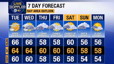
The forecast for the following week?
Now this is what i want to see!
12/21-22
Last night was the biggest whack we have gotten this year. It rained sideways, even more fiercely than before.
I can look out my apt window at a street lamp that clearly shows what is a-happenin'.
Egg-sellent!
1/02/16
Prediction is for a rainy week ahead. Sat PM, the forecast models have moved up the arrival of clouds, but it doesn't look very exciting.
The predictions come true, however.
This is my choice for Nor Cal weather - the have some excellent doppler radar images and animations:
Check this one out on a regular basis:
It's pretty scientific, but remains understandable to the lay person.
I happened to come across this, somewhere: NOAA satellite Image late August, 2015 - Three hurricanes in the Pacific - quite unusual!
"In late August, three category 4 hurricanes, Kilo, Ignacio, and Jimena, formed in the central and eastern Pacific Ocean. The Weather Channel reported it was the first time three such hurricanes were seen in the Pacific at one time. El Niño predictions forecast an above-normal hurricane season."
Here's a satellite image from recently, about a week ago:
Same thing going on, three low pressure systems parading across the ocean - California here we come!
In spite of all the above:
"Beyond all the hype over a possible drought-busting El Niño this winter is a much grimmer prospect for California: a dry La Niña come fall."
Next fall/winter is along way off, isn't it?


No comments:
Post a Comment